-
Cart
Your cart is emptyLooks like you have not added anything to your cart. Go ahead and explore our products to add to your cart to get started!Go to Plans & Pricing -

Analytics built by: Location Inc. powered by CoreLogic
Raw Data sources: Much of our data is exclusive or proprietary to SecurityGauge®. We start by collecting raw data from all local law enforcement agencies that have law enforcement responsibility for all (or any part) of a municipality or location (18,000 plus law enforcement agencies).
Date(s) & Update Frequency: Reflects 2024 calendar year; released in September 2025 (latest available). Updated annually.
Methodology: Our nationwide meta-analysis overcomes the issues inherent in any crime database, including non-reporting and reporting errors. This is possible by associating the 9.4 million reported crimes in the U.S, including over 2 million geocoded point locations. These data are then input to our spatial modeling to produce 10 meter resolution crime risk data for every address in the U.S. and Canada. Read more about our crime risk assessment methodology.
SecurityGauge® Crime Risk Reports provide an instant, objective and quantitative assessment of property and violent crime risks for any U.S. address. We never use data on race, ethnicity, ancestry, language, or religion for any of its crime risk analytics.
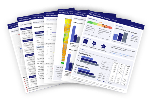
The SecurityGauge® Crime Risk and Risk Profile Ratings are on a nationally comparable scale of 1 to 5, with 1 being the lowest risk and 5 being the highest risk. The ratings combine the 8 major types of crime tracked by SecurityGauge into a single score as they relate to risk at your address: vandalism, burglary, larceny-theft, motor vehicle theft, armed robbery, aggravated assault, homicide, and rape.
| 1 | Low: less than half the national average |
| 2 | Moderate: half the national average to slightly above the national average |
| 3 | Elevated: slightly above national average to twice the national average |
| 4 | High: twice the national average to three times the national average |
| 5 | Severe: more than 3 times the national average |
The ratings are based on a distance weighted cone of influence surrounding the site. The crime risk calculation is weighted the heaviest nearest to the site, and lessens as it progresses outward. The cone of influence is illustrated by three circular rings on all Crime Maps (see C).
These 1–5 ratings also relate to our detailed indices of crime risk which are on a 0–5,000 scale (see D).
Crime Maps provide 10 meter resolution depiction of crime risk in your vicinity. The maps represent a continuous surface of crime risk simplified to 25 color bands that denote crime index values of 0 to 5,000 surrounding the address, where 100 equals the national average.
Values are calculated based upon a distance weighted cone of influence around any specified address. The cone of influence is divided into three rings which are plotted on all Crime Maps.
1. Inner Ring - The crime risk calculation is weighted most heavily within the Inner Ring, nearest the address. It has a radius ranging from as little as 300 feet up to a maximum of 2,700 feet, based on population density directly around the site.
2. Middle Ring – The middle ring’s crime risk is weighted moderately, and has a maximum radius of 1 mile or a population threshold of 25,000 people.
3. Outer Ring – The outer ring’s crime risk calculation is weighted the least. It has a maximum radius of 3 miles or a population threshold of 100,000 people.
Crime risk is quantified on a 0-5,000 scale, where 0 is the lowest risk, 100 is the average and 5,000 is highest. Each category reflects how crime at your location compares to the Nation, State, and County. E.g., a score of 50 is ½ the average risk, 200 is double the average, and 500 is 5x the average.
Here’s how the Index Scores relate to our exclusive Crime Risk Ratings (see A) :
Key Indices are provided for seven major crime types: homicide, rape, armed robbery, aggravated assault, burglary, larceny-theft, and motor vehicle theft, plus a detailed scoring for total crime, overall violent crime, and overall property crime. Read Crime Types below for definitions of each type of crime.
Property and violent crimes are broken down here to show you the rate of each crime type predicted at your Site Location per 1,000 residents. This rate is then compared to your state and the nation overall.
Three graphs plot past, present and future crime risk trends in 5-year intervals, starting with 5 years ago, to today, to 5 years forecast in the future. The graphs reveal total crime, plus trend lines for burglary, larceny-theft, motor vehicle theft, armed robbery, aggravated assault, homicide, and forcible rape. The Risk Index uses a 0 to 5,000 scale where 100 is the national average and 0 is lowest risk.
Historical and forecasted values here examine your site's risk score at five years ago and five years ahead for each crime type. The chart includes indices comparing your site to the nation, the state where the address is located, and the county where the address is located. Both tables break down risk index scores of various crimes against persons, followed by a cumulative total, and of various crimes against property, followed by a cumulative total.
This map provides a detailed 10 Meter resolution picture of forecasted total crime risk 5 years in the future surrounding your address. The map makes it easy to pinpoint emerging areas of concern, shifting risks, and identify how and to what degree the area may be trending toward greater safety and lower crime risk.
Perimeter Risk Factors identify the facilities and amenities in the vicinity of your site that may affect crime risk. Arenas, public transportation and other facilities that draw crowds of people may increase crime risk, while some experts believe facilities such as police stations and museums may reduce crime risk. This information is based on public record data and custom mapped for your site. The report includes a table of the mapped risk factors by type, name, and distance from your address. While Perimeter Risk Factor data are sourced from public record and are generally reliable, we recommend that the information be verified by external sources.
Burglary The unlawful entry of a structure to commit a felony or a theft.
Larceny-Theft The unlawful taking of property from the possession of another (excluding motor vehicles).
Vandalism The willful or malicious destruction of public or private property.
Vehicle Theft The theft or attempted theft of a motor vehicle.
Aggravated Assault An attack by one person upon another for the purpose of inflicting severe or aggravated bodily injury.
Armed Robbery The taking or attempting to take anything of value from a person(s) by force or threat of violence.
Homicide The willful (nonnegligent) killing of one human being by another.
Rape All forms of non-consensual sexual penetration. This definition applies to data reported late 2014 and beyond.
Businesses need accurate crime risk data for each individual address, not city wide averages. Unfortunately, measuring crime risk at this hyper-local level has been hindered nationally by agency-centric reporting and the lack of known locations for where crimes have occurred. As a result, crime researchers are often limited to calculations built only from a single local law enforcement agency’s data – data that use a ‘one model fits all’ approach that dilutes precision and often have limited validation in the real world.
We begin by collecting raw crime data reported from all 18,000 law enforcement agencies in America. Then we use a relational database to assign reported crimes from each agency to the city where it has law enforcement responsibility. This method provides an accurate representation of the complete number and types of crimes that are truly known to occur within any city or town.

With this comprehensive foundation, we use more than 80 proprietary computer models developed by our Ph.D. experts over nearly a decade of research to statistically predict the number and rates for every major type of crime for every community in America.

Since we know the number of reported crimes that actually occur in each community because of our exclusive approach, we are uniquely able to validate our models against the only comprehensive location-centric crime database with complete U.S. coverage. Our crime data is validated on more than 8,000 cities nationwide.
With validated precision models for every major crime type, SecurityGauge then builds crime risk data for nearly a quarter of a million neighborhoods all across the U.S. This forms a dense net of crime data that is input to our spatial risk models resulting in a national data base of 10 meter resolution crime risk statistics for the entire U.S.
Although we have attempted to ensure the accuracy, reliability, and timeliness of the information presented in this report, you expressly agree that use of this Report is at your sole risk. Neither SecurityGauge, its affiliates, and/or subsidiaries, nor any of their respective employees, representatives, owners, shareholders, directors, officers, members, managers, or licensors warrant that the Report will be error free.
The Report is provided on an “as is” basis without warranties of any kind, either expressed or implied, including, but not limited to, implied warranties of merchantability or fitness for a particular purpose, other than those warranties which are implied by, and incapable of exclusion, restriction or modification under, applicable law. You further expressly agree that the content contained in any SecurityGauge® Report is a work of art, and as such, no warranties are expressed or implied, including, but not limited to, with regard to the risk, suitability, desirability, danger, hazard, threat, safety, and/or value of any property, location, neighborhood, or area for any purpose whatsoever.
You are solely and absolutely responsible for assessing the accuracy and/or reliability of the geocoding services (defined as the conversion of a street address and/or place name to geographic latitude and longitude coordinates) used by SecurityGauge. In the event a “confidence score” is provided in relation to any geocoding services and/or determination of the location of any address, it is purely for your consideration in evaluating the accuracy of the geocoding services and/or the accuracy of the interpreted location of any address, and is in no way a representation and/or warranty of the accuracy and/or reliability of the geocoding services and/or the interpreted location of any address.
You agree to defend (with counsel of SecurityGauge’s choosing), indemnify, and hold harmless SecurityGauge, its affiliates, and their respective employees, owners, and/or officers from and against all claims, losses, liabilities, costs and expenses attributable to your use and/or misuse of the Report.
In no event will SecurityGauge, or any person or entity involved in creating or distributing the Report or the content included therein, be liable for any damages, injuries, harm to persons or property, expenses, and/or losses, including, without limitation, direct, indirect, incidental, special, punitive, consequential, or similar damages, including, without limitation, lost profits or revenues, loss of use, or economic loss, arising out of the use of the Report.
This Report has been prepared by SecurityGauge for the exclusive use of the intended recipient. You expressly agree not to copy, distribute, or publish the Report or any of its contents in any form without prior written permission from SecurityGauge.
This Report contains proprietary information (including, without limitation, copyrighted material, trademarks, patented and patent-pending data, and other proprietary information), text, data, analyses, maps, information, software, photos, and graphics (the "Content"). The Content of the Report, as well as the organization, layout, arrangement and design elements of the Report and each individual page of the SecurityGauge.com site, are the property of SecurityGauge and are protected by United States and international copyright, trademark and other applicable intellectual property laws.
You may not make use of any robots, spiders, or similar data mining or extraction tools or manual processes to collect, gather or copy any of the Content in an unauthorized manner. You may not engage in the practices of "screen scraping," "database scraping," or any other practice or activity the purpose of which is to obtain portions of a database, or other lists or information from the Report, in any manner or in any quantities not authorized in writing by SecurityGauge. Systematic retrieval of the Content or other data from the Site to create or compile, directly or indirectly, in whole or in part, a collection, compilation, database or directory without the express written permission of SecurityGauge is strictly prohibited.
SecurityGauge is a leading builder and primary source of location-based data and risk analysis information for corporate users nationwide.
SecurityGauge is a Ph.D.-led geographic research and data mining facility based in Massachusetts. We specialize in location-based big data analysis, demographic and crime data information products, and location-based decision-making tools.
More than 40 million people and businesses have used SecurityGauge data and services since the Company’s 2000 inception. Our client-base consists of Real Estate Investment Trusts, property and casualty insurance providers, corporate relocation departments, direct marketers, loss prevention analysts, private investors, and more.
To purchase discounted report bundles for many addresses, get access to our API for a direct feed of our data, or to learn about our subscription plans, please contact our Data Sales Team.
Toll-Free:
1+ (508) 753-8029
Email:
customerservice@securitygauge.com
Company Website:
www.cotality.com
Product Website:
www.neighborhoodscout.com/securitygauge